Jiantanshan Hiking Trail (Wuzhi Mountains)
五指山系 劍潭山親山步道· Hiking trail
About
Jiantanshan rises 153 metres and lies in the Yuanshan scenic area of Shilin District, Taipei. It is the northern ridge of the hill behind the 圓山飯店 and the small hill closest to the centre of Taipei.
Read more
The ridge trail leads gently on to other peaks and is an easy walk. The trailhead is beside the Jiantan bus stop on Zhongshan North Road Section 4. The area was once a military restricted zone and protected forest, so the natural woodland and plant life are well preserved, and dense forest covers the whole trail. Since military control was lifted, development has changed the original forest, and many planted garden and economic plants now line the trail. The trail is used by residents for morning exercise, and the spot on the ridge known as Lao Difang ("the old place") is a well-known exercise area. Morning exercise groups, hiking clubs and badminton clubs line the trail, making it feel like a city park or an outdoor living room on the hill. Older residents sing karaoke, play mahjong, chat and drink tea here. Views along the way include the 圓山飯店 and the riverside parks on the Keelung River. The trail ends at Lane 165, Tongbei Street, at the junction with Bei'an Road in Dazhi. It is a gently sloping, easy hill trail. Rest areas and pavilions line the route. The green hills around the 圓山飯店, seen from the MRT Tamsui Line or from the freeway into Taipei, are Jiantanshan. Squirrels may be seen in the trees, and the Taiwan barbet (五色鳥) and the white-eye (綠繡眼) are common birds here. From the high points the city lights can be seen at night, and planes fly low overhead from time to time. More people come to walk here at night than in the daytime or morning, often combined with food at Shilin Night Market. Watching planes take off and land is one of the draws of the hill. Towards 實踐大學 is a viewing area that hikers call the plane-watching deck (觀機坪), with open views and almost nothing in the way. The boardwalk near the summit has wider views, taking in the distinctively shaped Dazhi Bridge and the Taipei 101 tower. The whole of Dajia Riverside Park is in view: the riverside green space created when the Keelung River was straightened, Xiwang Fountain, Dazhi Bridge (Taipei's first fishing-rod-style cable-stayed bridge), and the reviewing stand and plaza used for the annual dragon boat races. The 圓山大飯店 is also in view. From the hill at the back there are views across Taipei, with the riverside park fountain and green embankments to the left, the Keelung River to the right, and Guanyinshan further away.
Translated and shortened by DealTaipei from Taiwan's national tourism database. Sources are on the terms page.
Facts and sources
- Names
- EN Jiantanshan Hiking Trail (Wuzhi Mountains)中文 五指山系 劍潭山親山步道한국어 젠탄산 등산로 Chinese from the listing; English by DealTaipei
- District
- Zhongshan District · 中山區 Tourism Administration listing, updated 2026-05-22
- Opening hours
- Not in the listing Tourism Administration listing, read 2026-09-30
- Phone
- (02)27593001 Tourism Administration listing. May be Chinese only
- Data
- /api/sight/jiantanshan-hiking-trail-wuzhi-mountains.json The same facts as JSON, for apps and AI agents
Getting there

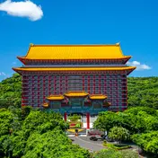 Grand Hotel Architecture · 148 m away Yuanshan Natural Landscape Park Park and garden · 531 m away Yuanshan Water Shrine Temple · 624 m away MAISON ACME (Yuanshan Villa) Historic site · 668 m away Taipei Performing Arts Center Theatre and venue · 669 m away Sanjiaodu Ferry Landing Riverside and wharves · 700 m away


Sources and photo credits are on the terms page.