Guandu, Jinse Waterfront and Bali Left Bank Cycle Path
關渡 金色水岸 八里左岸自行車道· Cycle path
About
The Keelung River curves around Shezi Island before it joins the Tamsui River. On its north bank, west of Huanggang Creek, is an area of farmland within the city.
Read more
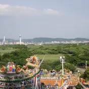
Rice fields stretch to the mangrove reserve at the river mouth, like a green corridor that keeps out the noise of the city. Cycling through it you get a sense of the simple life of an old farming village. At sunset, walking along the embankment in the evening breeze with birds singing, you can see Guandu Nature Park in the distance. The cycle path here is open. It runs east from Guandu Temple along the tidal embankment, turns north after Baxian Fude Shrine, and crosses the wide Guandu Plain to Zhongyang North Road in Beitou. The route ends at Daoxiang Road, west of the political warfare school (政戰學校). If you cannot bring your own bike, you can start from Guandu Temple, where bikes and tandems are easy to rent. Over time the riverbank in front of the temple has become a flat footpath, and the fishing boats once moored in the Zhonggang River have moved to the Tamsui River side, giving the waterfront a more open look.
Translated and shortened by DealTaipei from Taiwan's national tourism database. Sources are on the terms page.
Facts and sources
- Names
- EN Guandu, Jinse Waterfront and Bali Left Bank Cycle Path中文 關渡 金色水岸 八里左岸自行車道한국어 바리 쭤안 자전거길 Chinese from the listing; English by DealTaipei
- District
- Beitou District · 北投區 Tourism Administration listing, updated 2026-05-20
- Opening hours
- Not in the listing Tourism Administration listing, read 2026-09-30
- Phone
- (02)27258149 Tourism Administration listing. May be Chinese only
- Data
- /api/sight/guandu-jinse-waterfront-and-bali-left-bank-cycle-path.json The same facts as JSON, for apps and AI agents
Getting there


Sources and photo credits are on the terms page.